


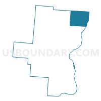
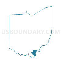
CHESHIRE TOWNSHIP, Gallia County, Ohio
About
Outline

Summary
| Unique Area Identifier | 646605 |
| Name | CHESHIRE TOWNSHIP |
| County | Gallia County |
| State | Ohio |
| Area (square miles) | 30.88 |
| Land Area (square miles) | 30.37 |
| Water Area (square miles) | 0.51 |
| % of Land Area | 98.35 |
| % of Water Area | 1.65 |
| Latitude of the Internal Point | 38.96902530 |
| Longtitude of the Internal Point | -82.15928970 |
Maps

Graphs
Select a template below for downloading or customizing gragh for CHESHIRE TOWNSHIP, Gallia County, Ohio


Neighbors
Neighoring Voting District (by Name) Neighboring Voting District on the Map
- Voting District 1, Mason County, WV
- ADDISON TOWNSHIP, Gallia County, OH
- BRADBURY Voting District, Meigs County, OH
- EAST RUTLAND Voting District, Meigs County, OH
- MORGAN TOWNSHIP, Gallia County, OH
- SALEM Voting District, Meigs County, OH
- SPRINGFIELD TOWNSHIP 3, Gallia County, OH
- WEST RUTLAND Voting District, Meigs County, OH
Top 10 Neighboring County Subdivision (by Population) Neighboring County Subdivision on the Map
- Salisbury township, Meigs County, OH (6,356)
- Springfield township, Gallia County, OH (3,664)
- Robinson district, Mason County, WV (3,222)
- Rutland township, Meigs County, OH (2,353)
- Addison township, Gallia County, OH (2,197)
- Morgan township, Gallia County, OH (1,404)
- Salem township, Meigs County, OH (1,051)
- Cheshire township, Gallia County, OH (1,002)
Top 10 Neighboring Place (by Population) Neighboring Place on the Map
Top 10 Neighboring Unified School District (by Population) Neighboring Unified School District on the Map
- Mason County School District, WV (27,324)
- Gallia County Local School District, OH (15,965)
- Meigs Local School District, OH (12,665)
Top 10 Neighboring State Legislative District Lower Chamber (by Population) Neighboring State Legislative District Lower Chamber on the Map
- State House District 92, OH (123,037)
- State House District 87, OH (120,818)
- State House District 13, WV (39,847)
Top 10 Neighboring State Legislative District Upper Chamber (by Population) Neighboring State Legislative District Upper Chamber on the Map
- State Senate District 17, OH (360,811)
- State Senate District 20, OH (357,708)
- State Senate District 4, WV (117,998)
Top 10 Neighboring 111th Congressional District (by Population) Neighboring 111th Congressional District on the Map
Top 10 Neighboring Census Tract (by Population) Neighboring Census Tract on the Map
- Census Tract 9549, Mason County, WV (7,391)
- Census Tract 9535, Gallia County, OH (4,827)
- Census Tract 9643, Meigs County, OH (4,808)
- Census Tract 9644, Meigs County, OH (3,521)
- Census Tract 9548.01, Mason County, WV (3,252)
Top 10 Neighboring 5-Digit ZIP Code Tabulation Area (by Population) Neighboring 5-Digit ZIP Code Tabulation Area on the Map
- 45631, OH (15,048)
- 25550, WV (9,077)
- 45614, OH (5,080)
- 45760, OH (3,892)
- 25287, WV (1,272)
- 45741, OH (918)
- 45620, OH (917)